
Planning for a World's Fair
History:
By 1958, local civic leaders had begun formulating an ambitious idea to boost the city's profile and economy by hosting an international exhibition. They soon sought to tie in the proposed world's fair with their desire to build a civic center using urban renewal funds. It would not be until 1962, with the establishment of San Antonio Fair Inc. as the coordinator, that plans began in earnest to develop the project and select a site for what would become the city's third urban renewal project: HemisFair '68.
Although several locations were proposed, including vacant land in the Valley Hi area off Old Highway 90 and a site north of the Municipal Auditorium near the river, the fair organizers eventually settled on 92.6 acres just southeast of the city center in 1963. This decision had far reaching implications not only for the city's future, but for the tight-knit historic neighborhood within the designated area.
Although several locations were proposed, including vacant land in the Valley Hi area off Old Highway 90 and a site north of the Municipal Auditorium near the river, the fair organizers eventually settled on 92.6 acres just southeast of the city center in 1963. This decision had far reaching implications not only for the city's future, but for the tight-knit historic neighborhood within the designated area.
About this Image:
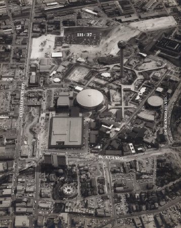
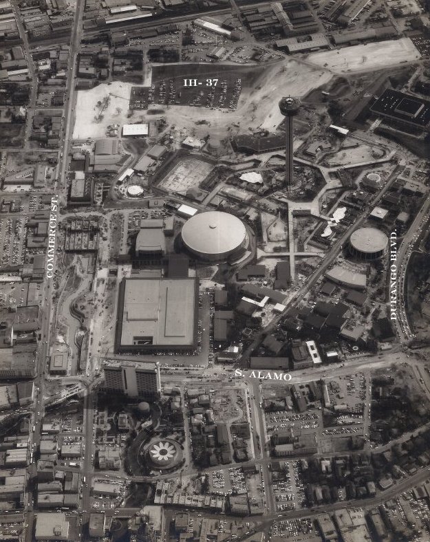
1) Aerial view of the HemisFair area. The land cleared for I-37 (at top) provided extra parking during the fair. The river extension - seen as a wavy line at the center left - replaced a strip of commercial buildings on the south side of Commerce Street. Photo by Harvey Konnitz.
2) This postcard shows a night view of the restored German-English School buildings on S. Alamo Street. San Antonio Fair, Inc. chose the restored school, located across the street from the fair, for its headquarters.
The limestone buildings originally served as a school for the children of German immigrants from 1859 to 1879.
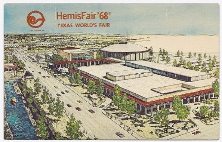
3) This postcard shows a colored rendering of the Convention Center complex (clockwise from the top: theater, arena, and convention hall). The new River Walk extension flows parallel to Market Street at the far left. c1967, Colour Picture Publishing Inc.
2) This postcard shows a night view of the restored German-English School buildings on S. Alamo Street. San Antonio Fair, Inc. chose the restored school, located across the street from the fair, for its headquarters.
The limestone buildings originally served as a school for the children of German immigrants from 1859 to 1879.
3) This postcard shows a colored rendering of the Convention Center complex (clockwise from the top: theater, arena, and convention hall). The new River Walk extension flows parallel to Market Street at the far left. c1967, Colour Picture Publishing Inc.
Credit:
Courtesy of San Antonio Conservation Society Foundation
Click to Enlarge
 1958-1968
 2) 1968
 3) 1968
 1958-1968
 2) 1968
 3) 1968