History:
Just past the convento, the far northeastern corner of the plaza remained relatively undeveloped until the 1920s, which was a time of expansion and growth in San Antonio, as the population grew by over 70,000.
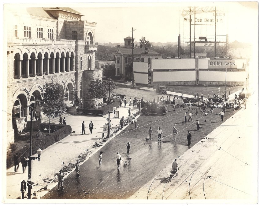
A devastating flood in 1921 caused "millions of dollars' worth of property damage" to homes, buildings, bridges, and streets, particularly those in the path of the San Antonio River as it wound through downtown (Heusinger, 64). The city responded to the flood with new construction and infrastructure improvement projects, such as repaving streets. Originally paved in mesquite blocks, many of the major streets required resurfacing with an early form of asphalt after the blocks washed away in the flood ("Lasting Streets").
A devastating flood in 1921 caused "millions of dollars' worth of property damage" to homes, buildings, bridges, and streets, particularly those in the path of the San Antonio River as it wound through downtown (Heusinger, 64). The city responded to the flood with new construction and infrastructure improvement projects, such as repaving streets. Originally paved in mesquite blocks, many of the major streets required resurfacing with an early form of asphalt after the blocks washed away in the flood ("Lasting Streets").
About this Image:
Workmen spread bitulithic mix, or asphalt, to seal the new pavement on Houston Street. From left to right are the U.S. Post Office and Courthouse, a two-story boarding house, and multiple billboards. These signs occupy the future site of the Medical Arts building.
Credit:
Courtesy of San Antonio Conservation Society Foundation
Click to Enlarge
 c. 1920-1929
 Site Map
 c. 1920-1929
 Site Map